Early representations of Rotto are on some old maps in the news today.
The SMH reports two forgotten hand-drawn charts were rediscovered by the map curator at the National Library of Australia.
"These charts are beautifully done with rhumb lines and two coloured compass roses," the SMH quotes the curator as saying.
"They show 1500 kilometres of the Western Australian coastline, from Perth to Exmouth, and they are remarkably accurate, to within a 10th of a degree of latitude.
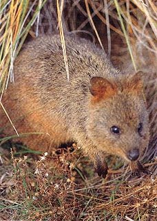
"The text describes some of the voyage's discoveries, including Rottnest Island and the Swan River, which was named for the first time by Vlamingh. Vlamingh was particularly fascinated by the quokkas on Rottnest, described in surviving journals as bush rats 'as big as cats'."
The South Land explored by Willem de Vlamingh in January and February 1697 were drawn in the seventeenth century.
Image from the Department of Conservation and Land Management


No comments:
Post a Comment